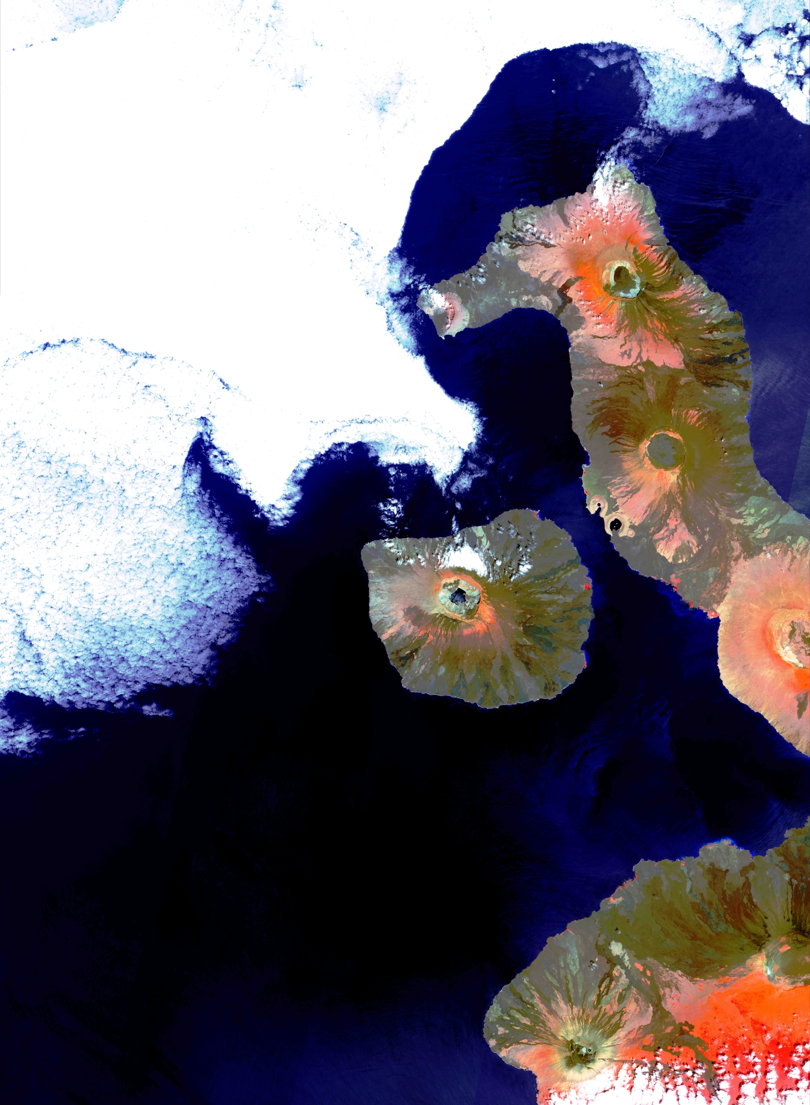
Ecuador – Galapagos
Le Galapagos sono un arcipelago di isole vulcaniche situate nell’oceano Pacifico, a circa 1.000 chilometri dalla costa occidentale dell’ America del Sud, appartenente politicamente all’Ecuador, distribuite a nord e a sud dell’equatore, che attraversa la parte settentrionale dell’isola più grande, Isabela; le più vecchie geologicamente datano circa 4 milioni di anni, mentre le più giovani sono ancora in via di formazione. L’arcipelago è infatti considerato una delle zone “vulcaniche” più attive della Terra. Il relativo isolamento dovuto alla distanza dal continente e l’ampia varietà di climi e di habitat dovuta alle correnti marine della zona hanno portato all’evoluzione di numerose specie endemiche di animali e vegetali, dalla cui osservazione Charles Darwin ha tratto ispirazione per la formulazione della teoria dell’evoluzione. Il suo celebre libro “L’Origine delle specie” contiene numerosissimi riferimenti ai propri studi sulle specie endemiche delle Galápagos. L’immagine rappresenta le isole Isabela, la più grande, e Fernandina. Isabela è costituita da una serie di vulcani a forma di ippocampo: i crateri, tra cui quello sventrato che costituisce il muso dell’ippocampo, sono perfettamente identificabili. Sulle due isole i versanti parzialmente boschivi sono striati di giallo-rosso per le colate di lava. Sotto un particolare in falsi colori.
Equador – Galapagos
The Galapagos are an archipelago of volcanic islands located in the Pacific Ocean, about 1,000 kilometers from the western coast of South America, belonging politically to Ecuador, distributed north and south of the equator, which crosses the northern part of the greatest island, Isabela; the oldest islands geologically date back around 4 million years, while the youngest are still in the process of forming. The archipelago is in fact considered one of the most active “volcanic” areas on Earth. The relative isolation due to the distance from the continent and the wide variety of climates and habitats due to the marine currents in the area have led to the evolution of numerous endemic species of animals and plants, from whose observation Charles Darwin drew inspiration for the formulation of theory of evolution. His famous book “The Origin of Species” contains numerous references to his studies on the endemic species of the Galápagos. The image represents Isabela, the largest, and Fernandina islands. Isabela is made up of a series of hippocampus-shaped volcanoes: the craters, including the gutted one that constitutes the snout of the hippocampus, are perfectly identifiable. On the two islands the partially forested slopes are streaked yellow-red due to lava flows. Below is a false color detail.
.
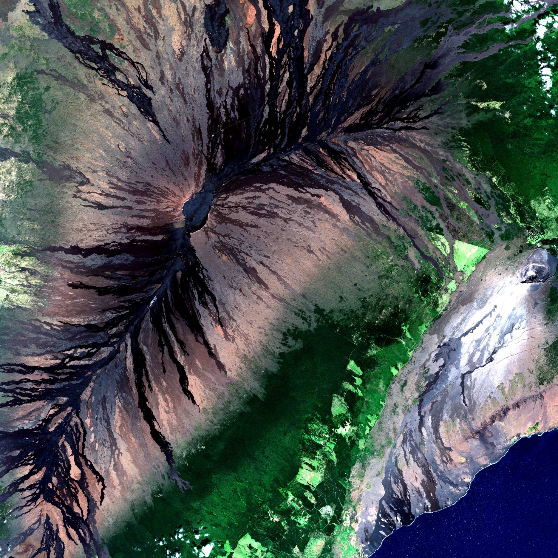
Hawai – Mauna Loa
Il cono ovoidale del vulcano Mauna Loa situato sull’isola di Hawai si sovrappone con quello di Kilauea, le cui colate si allungano fino al mare (a sud-est), isolando una valle coperta di boschi. Lunghe e molto omogenee le striature scure delle lingue di lava sottolineano la fluidità delle colate basaltiche hawaiane. Mauna Loa è uno dei vulcani attivi più imponenti della Terra, alto 4169 metri, ma presenta pendii poco inclinati, con la forma caratteristica di uno scudo.
Hawai – Mauna Loa
The ovoid cone of the Mauna Loa volcano located on the island of Hawaii overlaps with that of Kilauea, whose flows extend to the sea (to the south-east), isolating a valley covered in forests. Long and very homogeneous, the dark streaks of the lava tongues underline the fluidity of the Hawaiian basalt flows. Mauna Loa is one of the most impressive active volcanoes on Earth, 4169 meters high, but has slightly sloping slopes, with the characteristic shape of a shield.
.
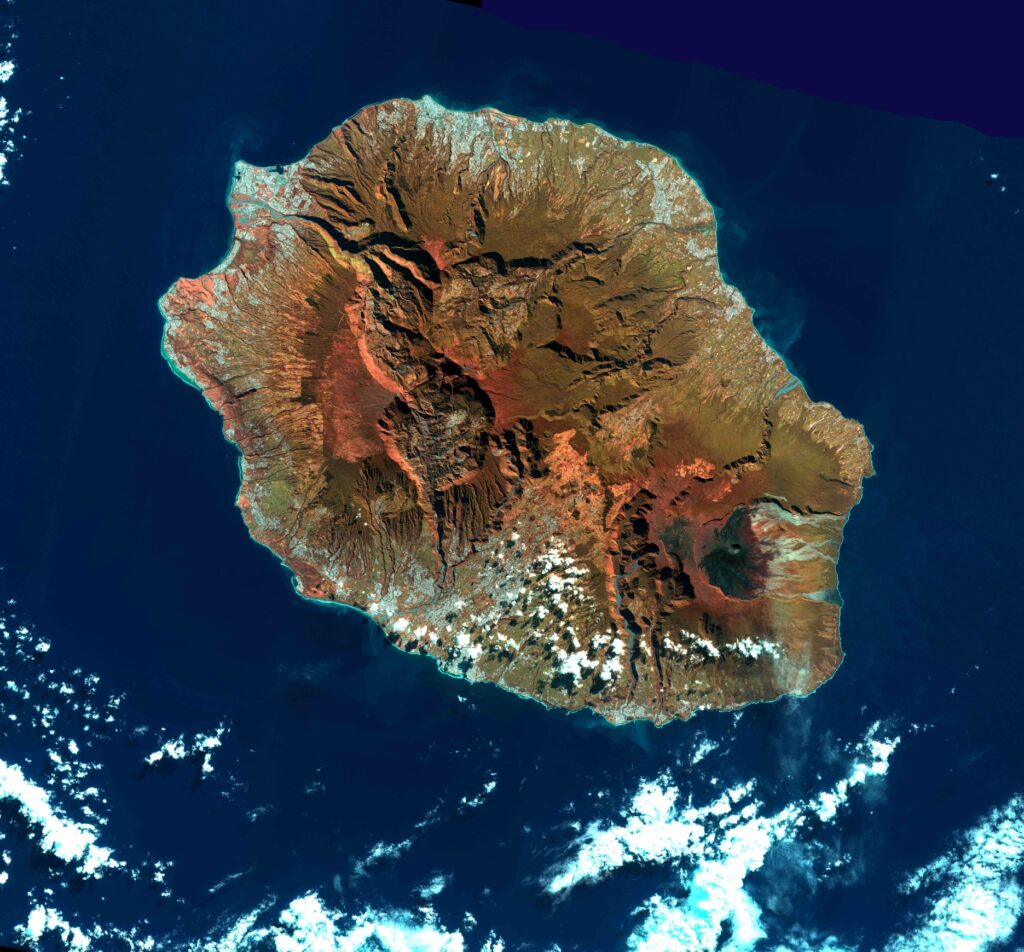
Oceano Indiano – Isola della Riunione
L’isola della Riunione è un dipartimento francese nell’Oceano Indiano con entroterra vulcanico ricoperto dalla foresta pluviale, circondata da spiagge e barriere coralline. Il luogo più emblematico è il Piton de la Fournaise, un vulcano attivo alto 2632 m. L’isola appare suddivisa in due sistemi montagnosi: il vulcano occidentale fortemente eroso e a est il cratere (nero) di Piton de la Fournaise le cui colate di lava formano un insieme di striature verso il mare.
Indian Ocean – Reunion Island
Reunion Island is a French overseas department situated in the Indian Ocean, with a volcanic hinterland covered by rainforest and surrounded by beaches and coral reefs. Its most emblematic place is the so-called “Piton de la Fournaise”, an active volcano 2632 m of height. The island appears divided in two mountainous systems: the strongly eroded western volcano and the black crater of “Piton de la Fournaise”, whose lava flows form a series of streaks that descend towards the sea.
.
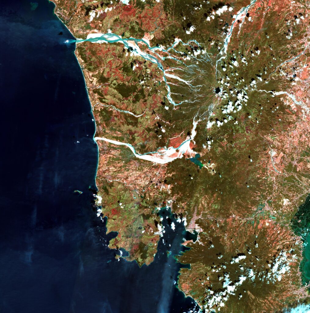
Filippine – Pinatubo
Il vulcano Pinatubo è un complesso attivo presso l’isola di Luzón delle Filippine. Caratteristico è il suo smaltimento di ceneri, lava e fango, sotto forma di colate che fluiscono canalizzate nelle valli. Questi materiali vulcanici vengono poi riversati nel Mare Cinese Meridionale attraverso i fiumi, che occupano i canali formati dalle colate. Il vulcano è alto 1.486 metri e la sua ultima forte attività eruttiva è stata registrata il 15 giugno 1991.
Philippine – Pinatubo
The Pinatubo volcano is an active complex on the island of Luzón in the Philippine. Characteristic is its disposal of ash, lava and mud, in the form of flows that flow channeled into the valleys. These volcanic materials are then poured into the South China Sea through rivers, which occupy the channels formed by the flows. The volcano is 1,486 meters high and its last strong eruptive activity was recorded on June 15, 1991.
.
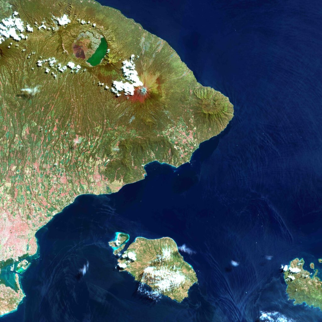
Indonesia – Bali
L’immagine raffigura la parte orientale dell’isola di Bali e l’isola di Nusa Penida in Indonesia. A sud-ovest la baia della capitale Denpasar. A nord i vulcani Batur e Agung. In alto, in verde, il lago Danau Batur alle pendici dell’omonimo vulcano. L’Indonesia è una zona vulcanica attiva e l’esplosiva eruzione del vulcano Agung nel giugno 2018 ha proiettato lava incandescente fino a due chilometri di distanza dal cratere, incendiando i boschi d’alta quota in montagna. L’immagine è stata acquisita circa due mesi prima dell’eruzione. A causa dell’intenso fumo e delle ceneri emesse durante l’eruzione, non è stato poi possibile ottenere immagini ottiche nel momento dell’evento.
Indonesia – Bali
The image depicts the eastern part of the island of Bali and the island of Nusa Penida in Indonesia. To the south-west is the bay of the capital Denpasar. To the north the volcanoes Batur and Agung. Above, in green, Lake Danau Batur on the slopes of the volcano of the same name. Indonesia is an active volcanic area and the explosive eruption of the Agung volcano in June 2018 projected incandescent lava up to two kilometers away from the crater, setting fire to high-altitude mountain forests. The image was acquired about two months before the eruption. Due to the intense smoke and ash emitted during the eruption, it was not possible to obtain optical images at the time of the event.
 using WordPress and