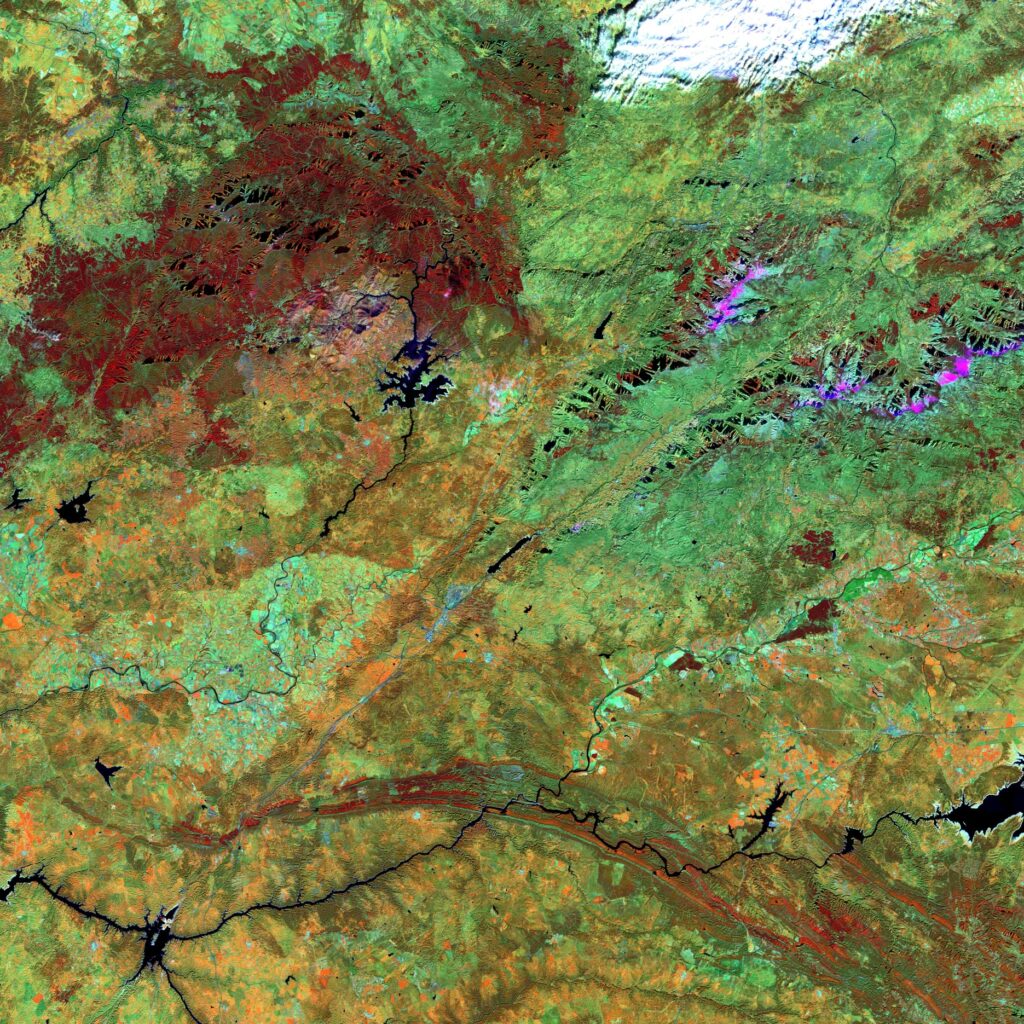
Spagna –Gabriel y Galan
A Nord dell’Estremadura, la fascia bianca che circonda il bacino Gabriel y Galan indica il livello d’acqua. Il corso “trattenuto” del Rio Alagon è destinato all’irrigazione agricola. Alle coltivazioni estensive tradizionali sono associate pratiche più intensive, ben rappresentate dalla sottile parcellizzazione rossa situata qualche chilometro a Est del bacino. Si notano inoltre alcune piccole città come Montehermoso e Ahigal, identificabili per il loro aspetto irregolare e per la convergenza delle strade. A nord, in bianco, le nuvole.
Spain – Gabriel y Galan
North of Extremadura, the white band surrounding the Gabriel y Galan basin indicates the water level. The “restrained” course of the Rio Alagon is intended for agricultural irrigation. More intensive practices are associated with traditional extensive cultivation, well represented by the thin red parcelling located a few kilometers east of the basin. There are also some small towns such as Montehermoso and Ahigal, identifiable by their irregular appearance and the convergence of the streets. To the north, in white, the clouds.
.
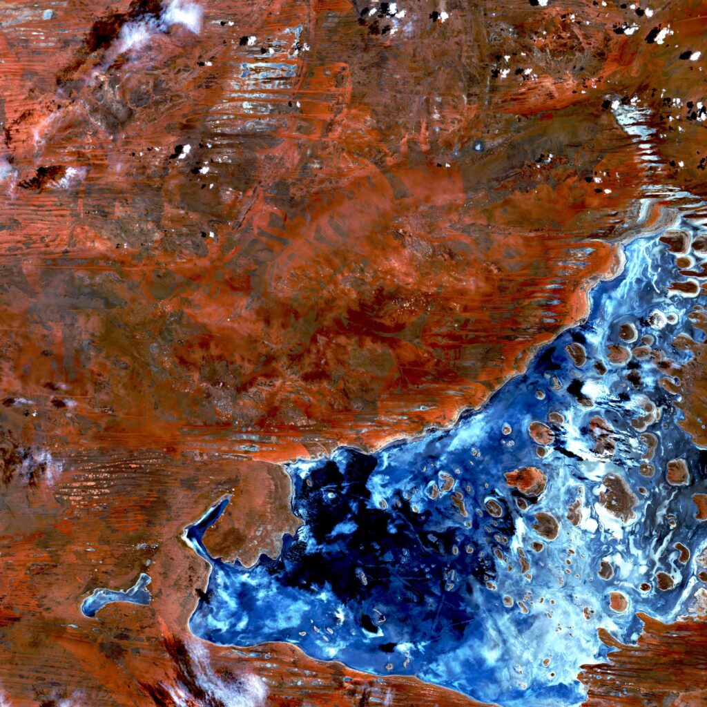
Australia – Lago Mackay
Il Lago Mackay è un bacino idrico stagionale in un’area remota dell’Australia occidentale. La scoperta del lago è attribuita all’esploratore Frank Hann nel 1897. Hann stava esplorando la parte orientale del Pilbara, nei dintorni del Fiume Rundall. Notò che alcuni torrenti scorrevano verso l’entroterra e ne seguì il corso, nella speranza di trovare un lago d’acqua dolce. Egli denominò il bacino che scoprì Lago del Disappunto, perché invece trovò un bacino endoreico di acqua salata, il lago Myke.
Australia – Mackay Lake
Lake Mackay is a seasonal body of water in a remote area of Western Australia. The discovery of the lake is attributed to the explorer Frank Hann in 1897. Hann was exploring the eastern part of the Pilbara, around the River Rundall. He noticed that some streams flowed inland and followed their course, hoping to find a freshwater lake. He named the basin he discovered “Lake of Disappointment”, because instead he found an endorheic saltwater basin, Lake Myke.
.
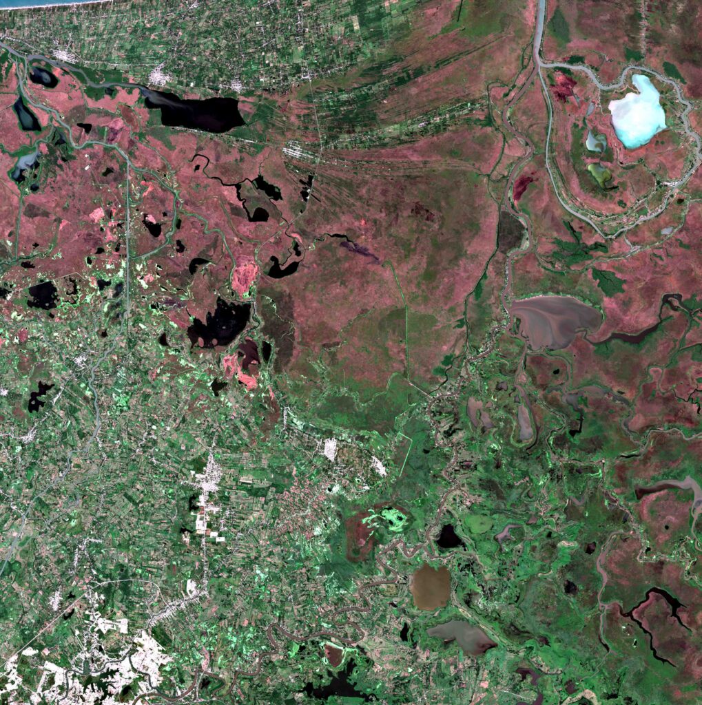
Messico – Rio Grijalva
Lo Stato di Tabasco è situato a circa 50 kilometri dal golfo di Campeche, sulla riva sinistra del Rio Grijalva che attraversa due complessi paesaggistici ben distinti. Il Sud-Ovest, solcato di strade, è dedicato alla policoltura. A nord-est il materiale alluvionale depositato dal Rio Grijalva costituisce una distesa, a volte paludosa, disseminata di laghi. Le terre sono state bonificate per permettere l’allevamento estensivo dei bovini. Questo spazio è particolarmente segnato da fenomeni di inquinamento legati allo sfruttamento petrolifero del golfo di Campeche.
Mexico – Rio Grijalva
The State of Tabasco is located about 50 kilometers from the Gulf of Campeche, on the left bank of the Rio Grijalva which crosses two very distinct landscape complexes. The South-West, crossed by roads, is dedicated to polyculture. To the north-east, the alluvial material deposited by the Rio Grijalva constitutes an expanse, sometimes marshy, dotted with lakes. The lands have been reclaimed to allow extensive cattle breeding. This space is particularly marked by pollution phenomena linked to the oil exploitation of the Gulf of Campeche.
.
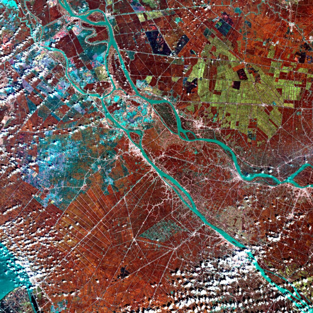
Vietnam/Cambogia – Fiume Mekong
A più di 100 km dal mare, tra Vietnam e Cambogia, serpeggiando tra le risaie, il delta del Mekong è già ben presente. Poiché gli appezzamenti agricoli sono molto piccoli, si distinguono praticamente solo i canali principali. L’estensione di questa tessitura lascia intendere un’intensa antropizzazione del territorio. L’immagine rivela terreni umidi spesso coperti d’acqua: la riduzione delle acque infatti lascia molte zone parzialmente umide (bluastre), mentre intorno la vegetazione, in rosso, appare molto vigorosa. In bianco le nuvole.
Vietnam/Cambogia – Mekong River
More than 100 km from the sea, between Vietnam and Cambodia, winding through the rice fields, the Mekong Delta is already very present. Since the agricultural plots are very small, practically only the main channels can be distinguished. The extension of this texture suggests an intense anthropization of the territory. The image reveals humid land often covered in water: the reduction of water in fact leaves many areas partially humid (bluish), while the vegetation around, in red, appears very vigorous. The clouds are white.
.
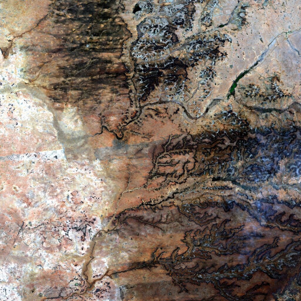
Niger – Tahoua
A sud del Niger, in prossimità di Tahoua, la rete idrografica ha intagliato gli altipiani ricoperti da uno strato di composti ferrosi. Ciascun versante della valle offre la visione di una sezione dello strato superficiale e della roccia sottostante. L’insieme di questi fenomeni produce un effetto simile a curve di livello, caratteristico dell’erosione lineare in zone tropicali. Nelle porzioni di altipiani tra due valli la steppa cespugliosa assicura una copertura discontinua del suolo e crea l’aspetto tigrato dell’immagine. Le tracce del flusso d’acqua marcano la stagione delle piogge che si presenta in ottobre.
Niger – Tahoua
South of the Niger, near Tahoua, the hydrographic network has carved the plateaus covered by a layer of ferrous compounds. Each side of the valley offers a view of a section of the surface layer and the underlying rock. The combination of these phenomena produces an effect similar to contour lines, characteristic of linear erosion in tropical areas. In the portions of plateaus between two valleys the bushy steppe ensures discontinuous ground cover and creates the brindle appearance of the image. The traces of the water flow mark the rainy season which occurs in October.
 using WordPress and