Ecuador – Galapagos Isola Isabela e Fernandina (IrRB)
L’isola Isabela è costituita da una serie di vulcani a forma di ippocampo: i crateri, tra cui quello sventrato che costituisce il muso dell’ippocampo, sono perfettamente identificabili. Sulle due isole i versanti parzialmente boschivi sono striati di giallo-rosso per le colate di lava.
Equador – Galapagos Isabela & Fernandina (IrRB)
In the Galapagos archipelago of Equador, Isabela Island is made up of a series of hippocampus-shaped volcanoes: the craters, including the gutted one that forms the snout of the hippocampus, are perfectly identifiable. On the two islands the partially forested slopes are streaked yellow-red due to lava flows..
.
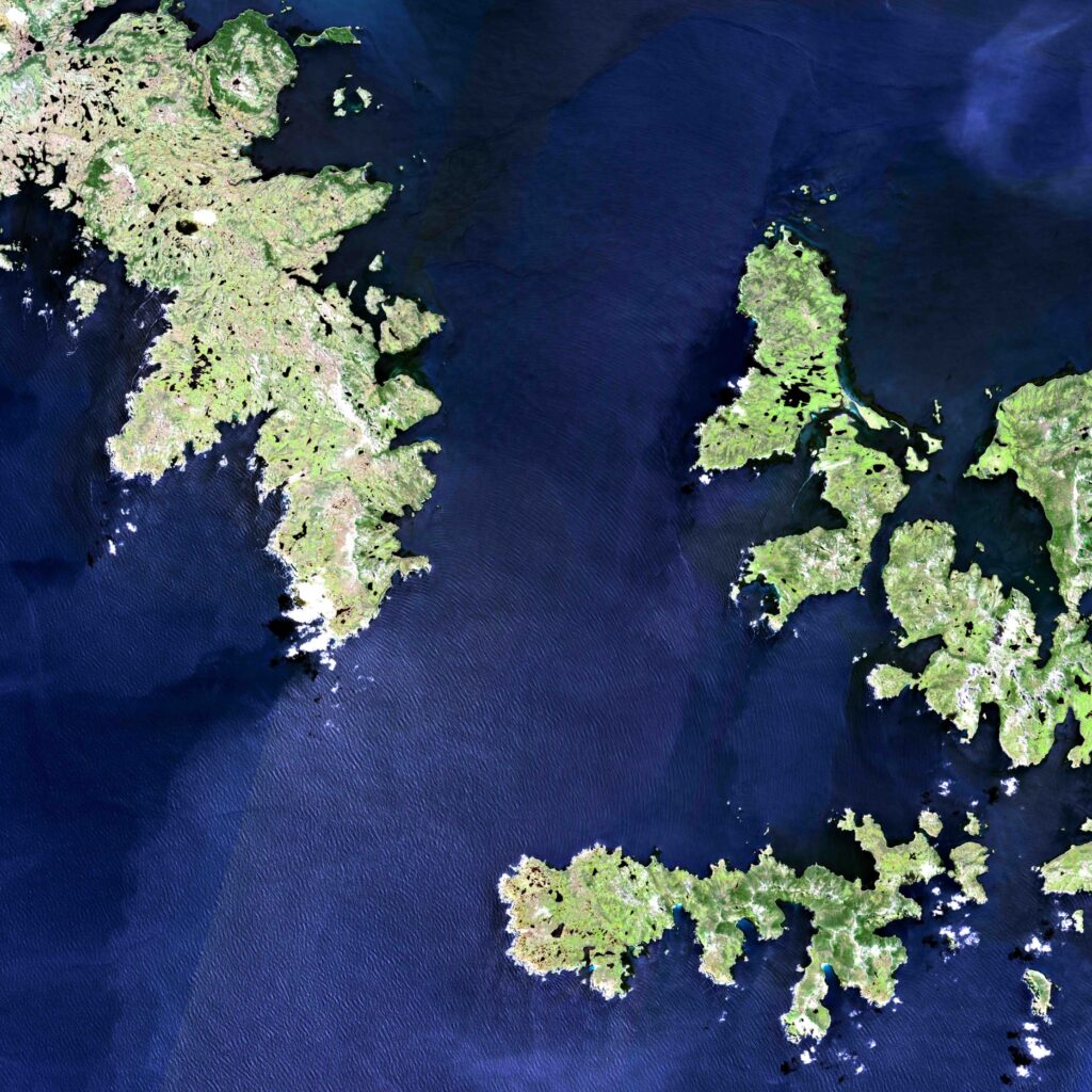
Cile – Capo Horn
L’arcipelago montagnoso nell’immagine costituisce l’estremo sud del continente americano in corrispondenza della fine delle Ande. Le falesie a picco sul mare si gettano nelle onde oceaniche. L’isola di Horn, quella del celebre capo, è la più meridionale. Queste isole cilene sono separate da canali in cui la navigazione è pericolosa per le condizioni climatiche particolarmente proibitive. Una celebre frase di Miles Smeeton che tentò per due volte di doppiare capo Horn nel 1951 senza riuscirci così le descrisse: “Era una visione fantastica… le grandi creste dirompenti… il mare rigato di spruzzi volanti, senza un attimo di sosta.” Questa è un’immagine eccezionale perchè le nuvole raramente sono così rade in questa regione del mondo.
Chile – Capo Horn
The mountainous archipelago in the image forms the southernmost tip of the American continent at the end of the Andes. The cliffs overlooking the sea throw themselves into the ocean waves. Horn Island, that of the famous cape, is the southernmost. These Chilean islands are separated by channels where navigation is dangerous due to particularly prohibitive climatic conditions. A famous phrase by Miles Smeeton who attempted to round Cape Horn twice in 1951 without success described it as follows: “It was a fantastic vision… the great explosive crests… the sea streaked with flying spray, without a moment’s rest.” This is an exceptional image because clouds are rarely this sparse in this region of the world.
.
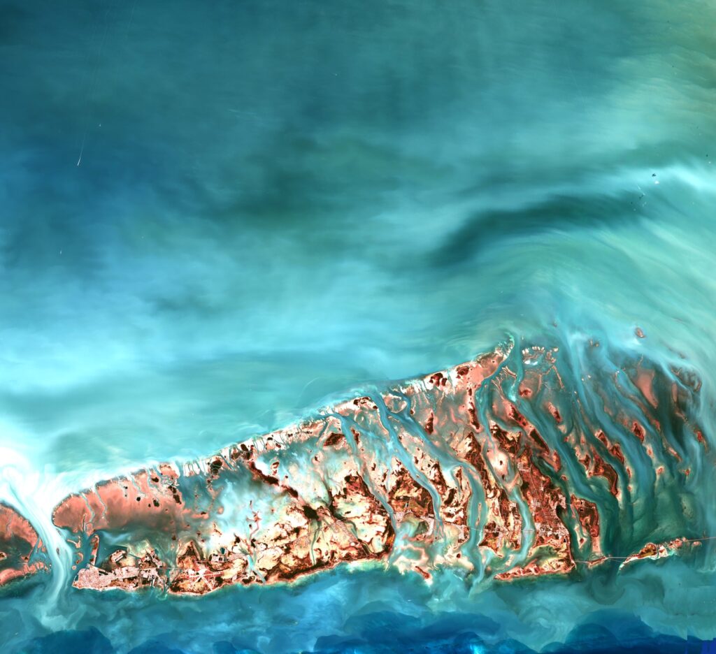
USA – Florida Keys
Le Keys della Florida sono delle isole basse, sabbiose e ancorate su formazioni coralline. Prolungano la Florida verso il Golfo del Messico. A sud di questo sito turistico corre un sottile tratto stradale di collegamento al continente. Questo asse raggiunge Key West dopo aver toccato gli insediamenti aeroportuali di Stock Island, verso Key Largo. Le Keys ospitano anche infrastrutture militari: la base di Key West, in basso a sinistra di Stock island si distingue dalle altre isole per la sua urbanizzazione.
USA – Florida’s Keys
The Florida Keys are low, sandy islands anchored on coral formations. They extend Florida towards the Gulf of Mexico. To the south of this tourist site runs a thin stretch of road connecting to the continent. This axis reaches Key West after touching the Stock Island airport settlements, towards Key Largo. The Keys also host military infrastructure: the Key West base, at the bottom left of Stock island, stands out from the other islands for its urbanization.
.
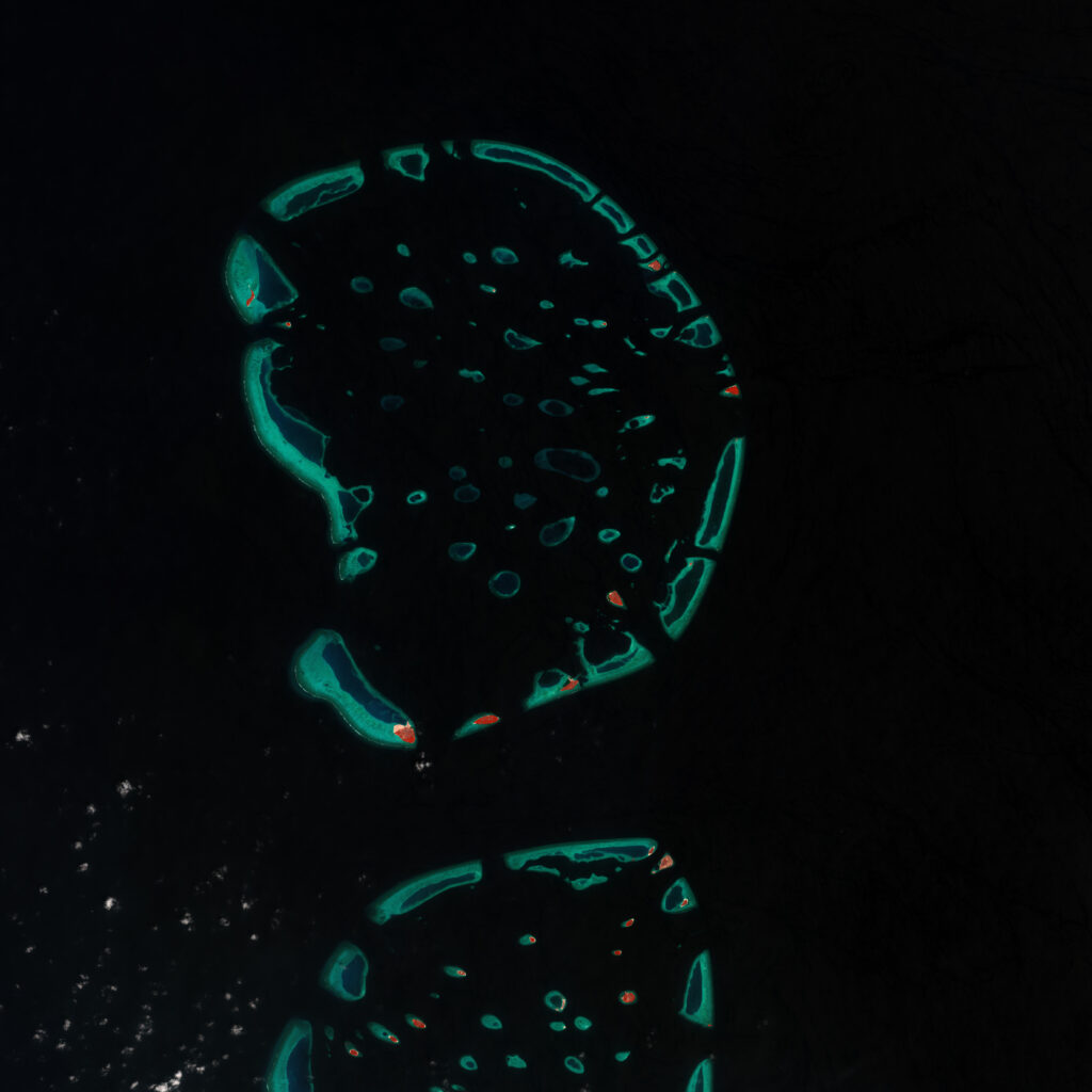
Maldive – Faafu
L’Atollo di Faafu (Nilandhe Atholhu Uthuruburi) e metà Atollo di Dhaalu a sud di Alifu (Ari) sono situati nel centro-ovest dell’arcipelago delle Maldive. In questa rappresentazione è evidenziata la parte più superficiale della barriera corallina verde-azzurra che circonda i numerosi affioramenti sabbiosi in parte vegetati. La vegetazione appare in rosso perché viene rappresentata in falsi colori la luce riflessa nell’intervallo spettrale dell’infrarosso.
Maldive – Faafu
Faafu Atoll (Nilandhe Atholhu Uthuruburi) and half of Dhaalu Atoll south of Alifu (Ari) are located in the central-west of the Maldives archipelago. This representation highlights the most superficial part of the blue-green coral reef that surrounds the numerous partly vegetated sandy outcrops. Vegetation appears in red because the light reflected in the infrared spectral range is represented in false colors.
.
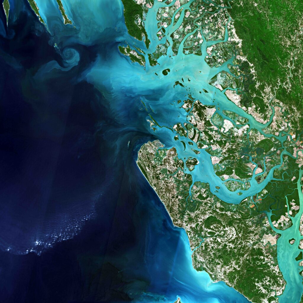
Myanmar – Baia di Combermere
A Est del golfo del Bengala, la baia di Combermere è popolata di isole basse, dominate da rilievi coperti di foreste. Il colore azzurro delle acque è dovuto ad importanti apporti alluvionali, ma anche alle variazioni dei fondi della baia, che non superano i 10 metri. Le foreste al centro delle isole sono contornate dalle mangrovie sui litorali fangosi e inframezzate con le risaie. Le sinuosità degli innumerevoli canali appena percepibili tra le mangrovie, risaltano tra le superfici denudate delle risaie.
Myanmar – Baia di Combermere
East of the Bay of Bengal, Combermere Bay is populated with low islands, dominated by forest-covered hills. The blue color of the waters is due to significant alluvial contributions, but also to variations in the bottom of the bay, which do not exceed 10 metres. The forests in the center of the islands are surrounded by mangroves on the muddy coasts and interspersed with rice fields. The sinuosities of the countless channels, barely perceptible among the mangroves, stand out among the bare surfaces of the rice fields.
.
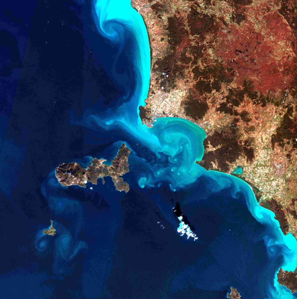
Italy – Isola d’Elba
L’isola d’Elba è collocata ad ovest della penisola italiana nel mar Tirreno in prossimità del golfo di Follonica. Le correnti marine generano i caratteristici riccioli azzurro-ciano che avvolgono l’Elba e a sud l’isola di Pianosa, e lungo la costa toscana. Al centro-sud dell’immagine, in bianco, appare una nuvola con la corrispondente ombra nera sul mare. In colore bruno-rossastro sono rappresentate le ampie zone boschive collinari, sia sull’isola che sull’area costiera toscana.
Italy – Elba island
The island of Elba is located west of the Italian peninsula in the Tyrrhenian Sea near the Gulf of Follonica. The sea currents generate the characteristic blue-cyan curls that envelop Elba and the island of Pianosa to the south, and along the Tuscan coast. In the center-south of the image, in white, a cloud appears with the corresponding black shadow on the sea. The large hilly wooded areas are represented in reddish-brown colour, both on the island and on the Tuscan coastal area.
.
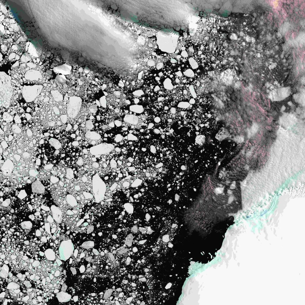
Antartico – Penisola di Trinity e isola Vega
L’estremità della Terra di Graham costituisce la parte del territorio Antartico più vicina al continente sud-americano, a circa 1100 km dalla Terra del Fuoco. Nel mese di gennaio, nel Golfo Erebo e Terrore, che separa la penisola di Trinity dall’Isola Vega, nell’estremo nord della terra di Graham, l’estate australe provoca la rottura della banchisa glaciale. Le acque libere dello stretto dell’Antartico sono disseminate di piccoli isolotti costituiti dai frammenti della banchisa. Gli isolotti scuri e rocciosi che emergono nelle acque libere aumentano l’impressione di caos.
Antarctica – Trinity peninsula and Vega island
The tip of Graham Land constitutes the part of the Antarctic territory closest to the South American continent, about 1100 km from Tierra del Fuego. In January, in the Erebus and Terror Gulf, which separates the Trinity Peninsula from Vega Island, in the far north of Graham Land, the austral summer causes the ice pack to break up. The open waters of the Antarctic Strait are dotted with small islets made up of fragments of pack ice. The dark, rocky islets that emerge in the open waters increase the impression of chaos.
.
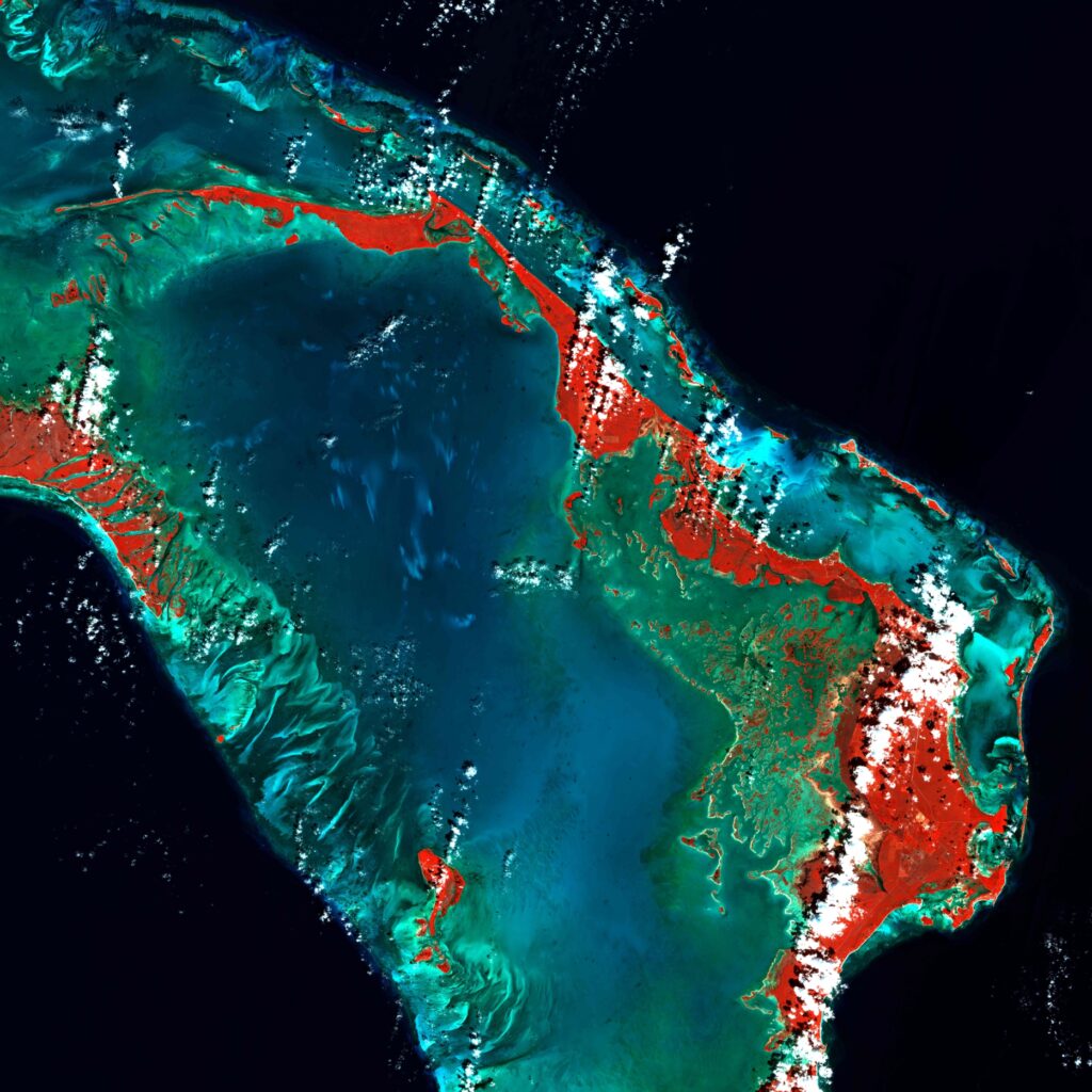
Bahamas – Porto Marsh
Le Bahamas sono circondate da una barriera corallina. L’arcipelago è perciò raggruppato in una specie di cordone avvolgente che ha come centro il mare con profondità limitate di colore blu brillante. Attorno il blu scuro delle acque profonde. La vegetazione è rappresentata in rosso perché l’immagine è elaborata in falsi colori includendo la banda spettrale del vicino infrarosso. Le striature bianche sono dovute alle nuvole.
Bahamas – Porto Marsh
The Bahamas islands are surrounded by a coral reef. The archipelago is therefore grouped in a kind of enveloping cord that has the sea as its center with limited depths and a bright blue colour. Around the dark blue of the deep waters. Vegetation is represented in red because the image is processed in false colors including the near infrared spectral band. The white streaks are due to the clouds.
 using WordPress and