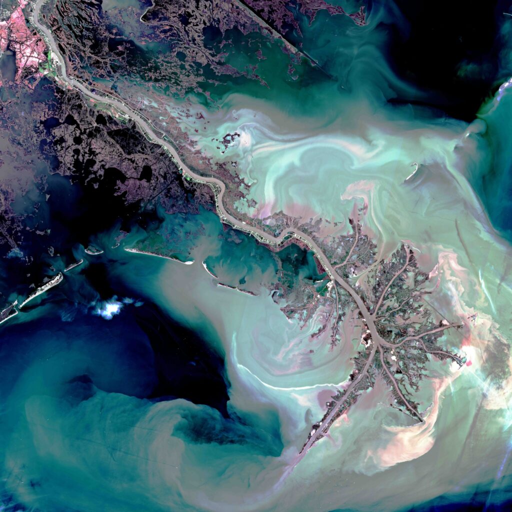
USA – Mississippi
A sud-est di New Orleans, nelle acque turchesi del Golfo del Messico il delta del Mississippi si distingue per il suo aspetto ramificato. L’influenza fluviale è dominante rispetto alle correnti marine e si rivela attraverso la formazione di lunghi canali. In questo modo il materiale alluvionale viene spinto verso i fondali marini anziché depositarsi nel delta. Questo fatto spiega anche l’aspetto spoglio del delta di questo fiume.
USA – Mississippi
Southeast of New Orleans, in the turquoise waters of the Gulf of Mexico, the Mississippi delta stands out for its branching appearance. The fluvial influence dominates over the marine currents and is revealed through the formation of long channels. This way, the alluvial material is pushed towards the seafloor instead of settling within the delta. This fact also explains the barren look of the delta of this river.
.
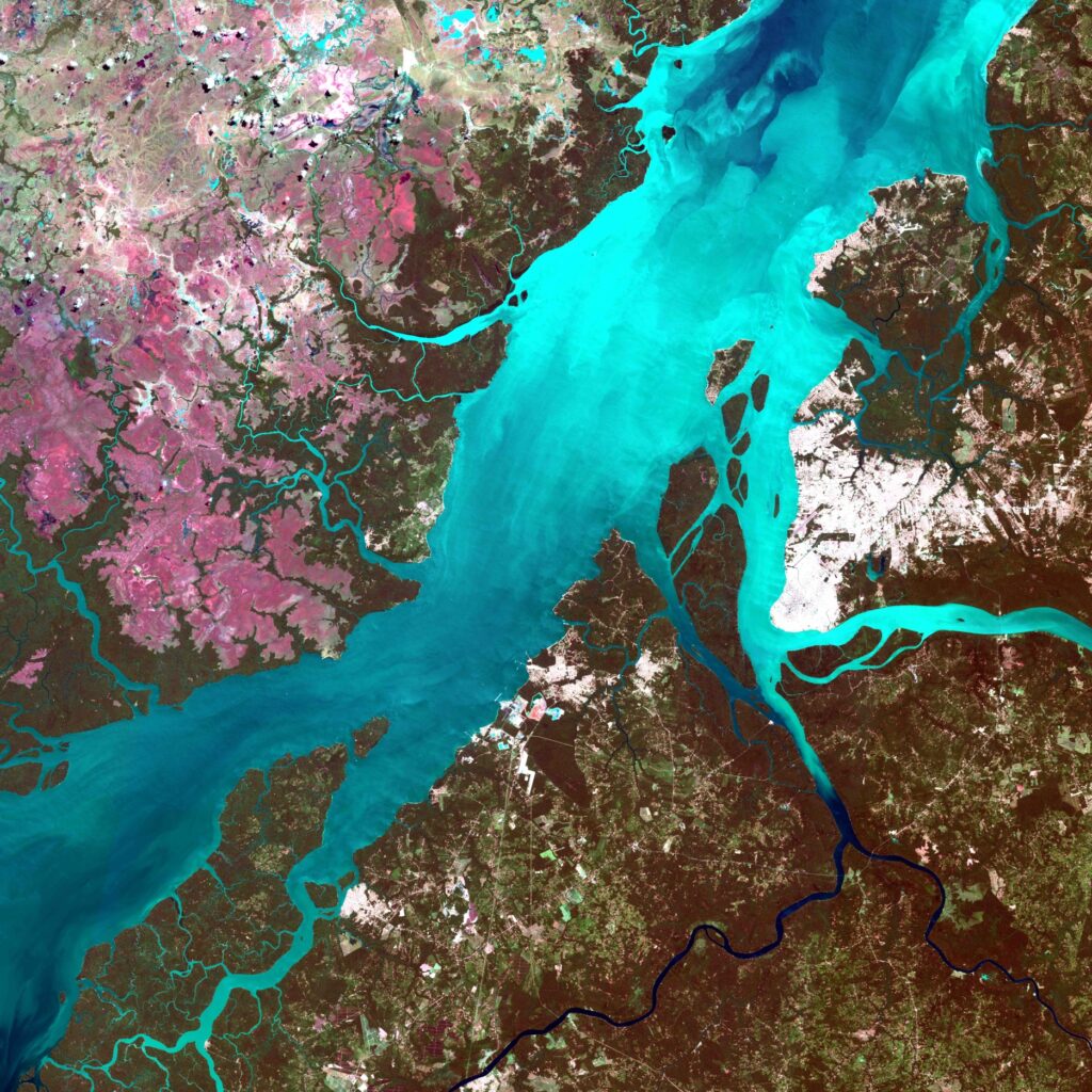
Brasile – Rio Para
A 250 km dall’Atlantico, l’acqua è ovunque. Siamo nel delta del Rio delle Amazzoni. Gli innumerevoli bracci fluviali prendono il nome di ‘furios’. Essi costituiscono una rete complessa tra il Rio delle Amazzoni e il Rio Parà. La trama fluviale separa il continente a sud dell’immagine, dall’isola di Marajò a nord. Quest’isola è proporzionata nelle dimensioni al Rio delle Amazzoni: si noti che è grande quanto la Svizzera! La foresta, di colore rosso granato, è interrotta da coltivazioni sparse. Gli appezzamenti più vasti sono concentrati nell’angolo a sud-ovest.
Brasil – Rio Para
250 km from the Atlantic, water is everywhere. We are in the Amazon River Delta. The countless river arms are called ‘furios’. They constitute a complex network between the Amazon River and the Para River. The river plot separates the continent to the south of the image from the island of Marajò to the north. This island is proportionate in size to the Amazon River: note that it is the size of Switzerland! The forest, garnet red in colour, is interrupted by scattered cultivations. The largest plots are concentrated in the south-west corner.
.
Iran/Irak – Shatt el Arab
All’estremo nord del golfo Persico la congiunzione tra il Tigri e l’Eufrate dà origine al cosiddetto Shatt al-‘Arab. Questa zona, parzialmente vegetata, costituisce la frontiera tra l’Iraq e l’Iran. L’isola Bubiyan, territorio del Kuwait, occupa l’angolo a sud-ovest dell’immagine. Questa zona bassa e paludosa è situata a un centinaio di chilometri dalla città di Al-Kuwait. La presenza d’acqua consente attività agricole lungo i tracciati dei fiumi. Da qui il contrasto tra le rive dello Shatt al-‘Arab e il resto del territorio desertico.
Iran/Irak – Shatt Al Arab
In the far north of the Persian Gulf, the junction between the Tigris and the Euphrates gives rise to the so-called Shatt al-‘Arab. This partially vegetated area constitutes the border between Iraq and Iran. Bubiyan Island, a territory of Kuwait, occupies the southwest corner of the image. This low-lying, marshy area is located about a hundred kilometers from the city of Al-Kuwait. The presence of water allows agricultural activities along the river routes. Hence the contrast between the banks of the Shatt al-‘Arab and the rest of the desert territory.
.
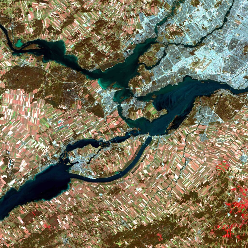
Canada – Fiume San Lorenzo
L’immagine mostra perfettamente la città fluviale di Montréal. La maglia bluastra del tessuto urbano si estende su tutta la Grande Isola e l’Isola Gesù, prima di raggiungere il ‘continente’ a ovest. Il porto di Montréal ha avuto come prima funzione quella di gestire la piena causata dal cedimento degli argini del fiume San Lorenzo. Con la realizzazione del canale marittimo sulla riva destra del fiume, questa funzione si è persa. Montréal rimane un porto molto attivo, sviluppato su diversi chilometri di riva, là dove il San-Lorenzo si allarga.
Canada – Saint Lawrence River
The image perfectly shows the river city of Montreal. The bluish mesh of the urban fabric extends across the entire Big Island and Jesus Island, before reaching the ‘continent’ to the west. The port of Montreal’s first function was to manage the flood caused by the collapse of the banks of the St. Lawrence River. With the construction of the maritime canal on the right bank of the river, this function was lost. Montreal remains a very active port, developed on several kilometers of shore, where the San Lorenzo widens.
.
Madagascar – Bombetoka Betsiboka
Sulla costa Ovest, a monte di Mahajanga, la Bombetoka (l’estuario fangoso della Betsiboka) è largo una decina di kilometri. Le isole alluvionali si estendono nel senso della corrente, precedute e seguite da banchi di sabbia; esse sono parzialmente ricoperte da mangrovie. Nelle aree fangose litorali, i bracci della rete idrografica, coperti di mangrovie, dànno un bel colpo d’occhio, quasi si trattasse di una rete ramificata di vasi sanguigni. Nei dintorni, la foresta largamente sfruttata lascia spazio alle coltivazioni di manioca e di riso.
Madagascar – Bombetoka Betsiboka
On the west coast, upstream from Mahajanga, the Bombetoka (the muddy Betsiboka estuary) is about ten kilometers wide. The alluvial islands extend in the direction of the current, preceded and followed by sand banks; they are partially covered by mangroves. In the muddy coastal areas, the arms of the hydrographic network, covered with mangroves, provide a beautiful sight, almost as if they were a branched network of blood vessels. In the surrounding area, the largely exploited forest leaves room for cassava and rice cultivation.
.
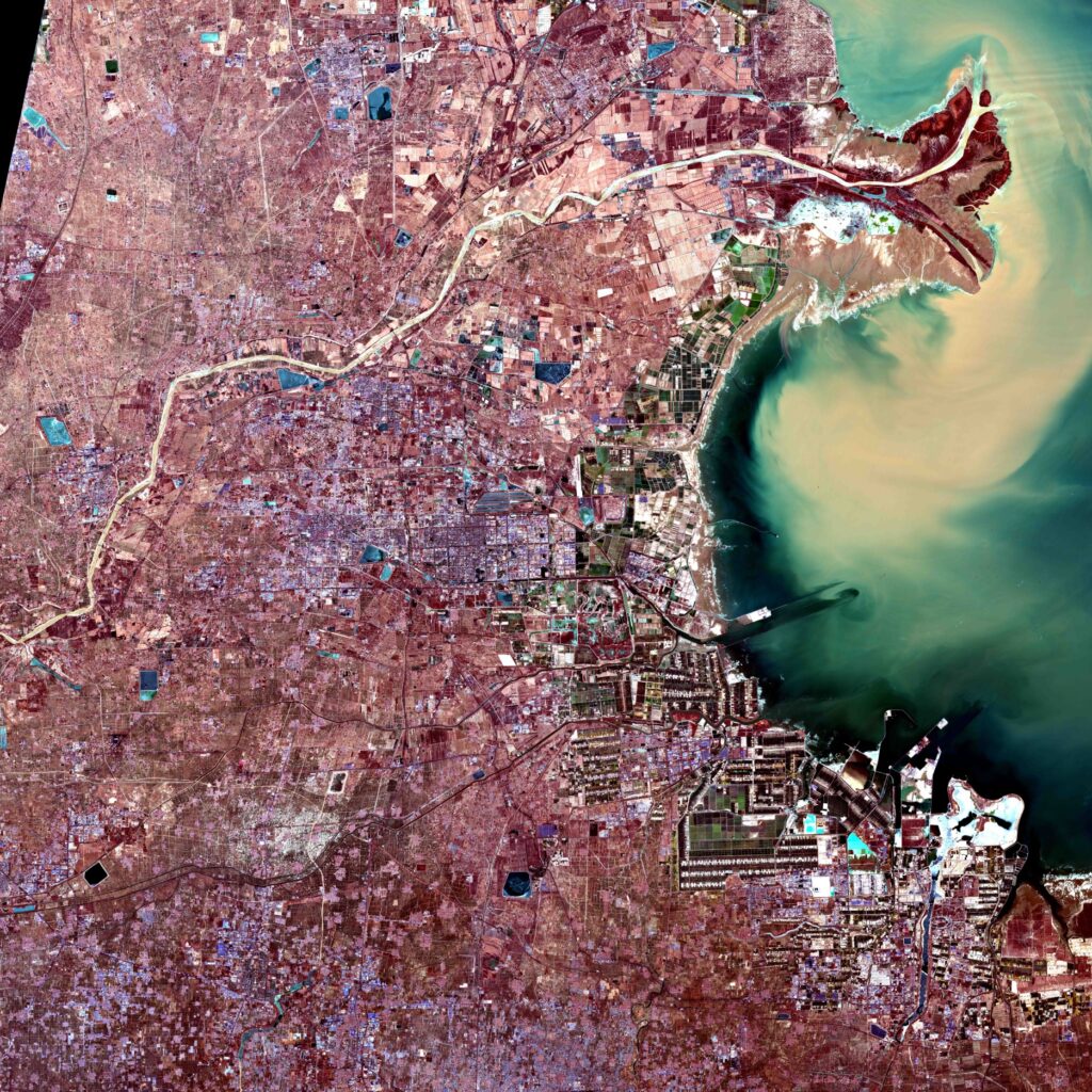
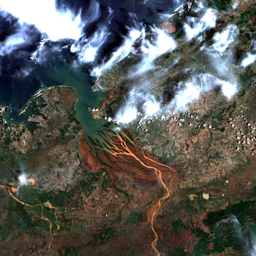
Cina – Fiume Giallo
Lo Huang He, o Fiume Giallo, sbocca nel golfo del Petchili / Bo Hai dopo un percorso di 4500 chilometri nella Cina settentrionale. Il forte carico alluvionale spiega il suo nome. Queste alluvioni favoriscono la crescita del delta: 19 km in un secolo! I magnifici pennacchi alluvionali confermano l’importante riversamento di fanghi. L’immagine testimonia l’evoluzione del delta, in cui solo la parte terminale rimane indenne da insediamenti. I terreni più vecchi sono dedicati alle coltivazioni, striate dalle infrastrutture stradali, e i bracci fluviali sono canalizzati.
China – Huang He
The Huang He, or Yellow River, flows into the Petchili / Bo Hai Gulf after a 4,500 kilometer journey in northern China. The strong alluvial load explains its name. These floods favor the growth of the delta: 19 km in a century! The magnificent alluvial plumes confirm the significant discharge of mud. The image testifies to the evolution of the delta, in which only the terminal part remains free from settlements. The older lands are dedicated to crops, streaked by road infrastructure, and the river arms are canalised.
.
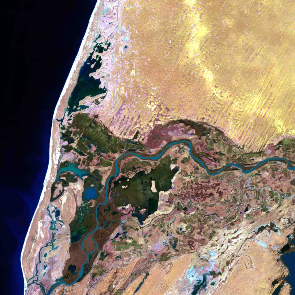
Mauritania – Fiume Senegal
Nel bacino del fiume Senegal, in Mauritania, la fase di piena in dicembre è ancora lontana dal suo esaurimento. I meandri del tributario fiume Garfa, che attraversano il territorio con scarsa pendenza da est a ovest, sono ancora inondati. Si notano situazioni diverse che vanno dal terreno nudo asciutto, alla copertura vegetale (rosso e rosa); i suoli gonfi d’acqua sono scuri. Le zone situate in prossimità del fiume sono ideali per le colture di piena, le più lontane vengono irrigate. A nord dell’immagine le dune del deserto.
Mauritania – Senegal river
In the Senegal River basin, in Mauritania, the flood phase in December is still far from being exhausted. The meanders of the tributary Garfa river, which cross the territory with little slope from east to west, are still flooded. Different situations are noted ranging from dry bare soil to vegetal cover (red and pink); the soils swollen with water are dark. The areas located near the river are ideal for flood crops, the furthest away are irrigated. To the north of the image are the desert dunes.
 using WordPress and