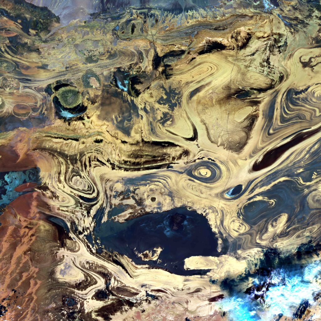
Iran – Dasht-E-Kavir
Dasht-é-Kavir, nel nord dell’Iran, è un grande deserto salato che si estende per oltre 300 km. In alcune cavità surriscaldate interne la temperatura è simile a quelle estreme nel Golfo Persico con temperature massime giornaliere intorno a 35 – 40 ° C. Il clima è secco e le precipitazioni, 100 mm/anno, coprono il terreno con un sottile film d’acqua in inverno e primavera: formando uno strato di alite (da cui il nome Kavir) e soprattutto la crosta di gesso.
Iran – Dasht-E-Kavir
Dasht-é-Kavir, in northern Iran, is a large salt desert that extends for over 300 km. In some internal overheated cavities the temperature is similar to the extreme ones in the Persian Gulf with maximum daily temperatures around 35 – 40 ° C. The climate is dry and precipitation, 100 mm/year, covers the ground with a thin film of water in winter and spring: forming a layer of halite (hence the name Kavir) and above all the chalk crust.
.
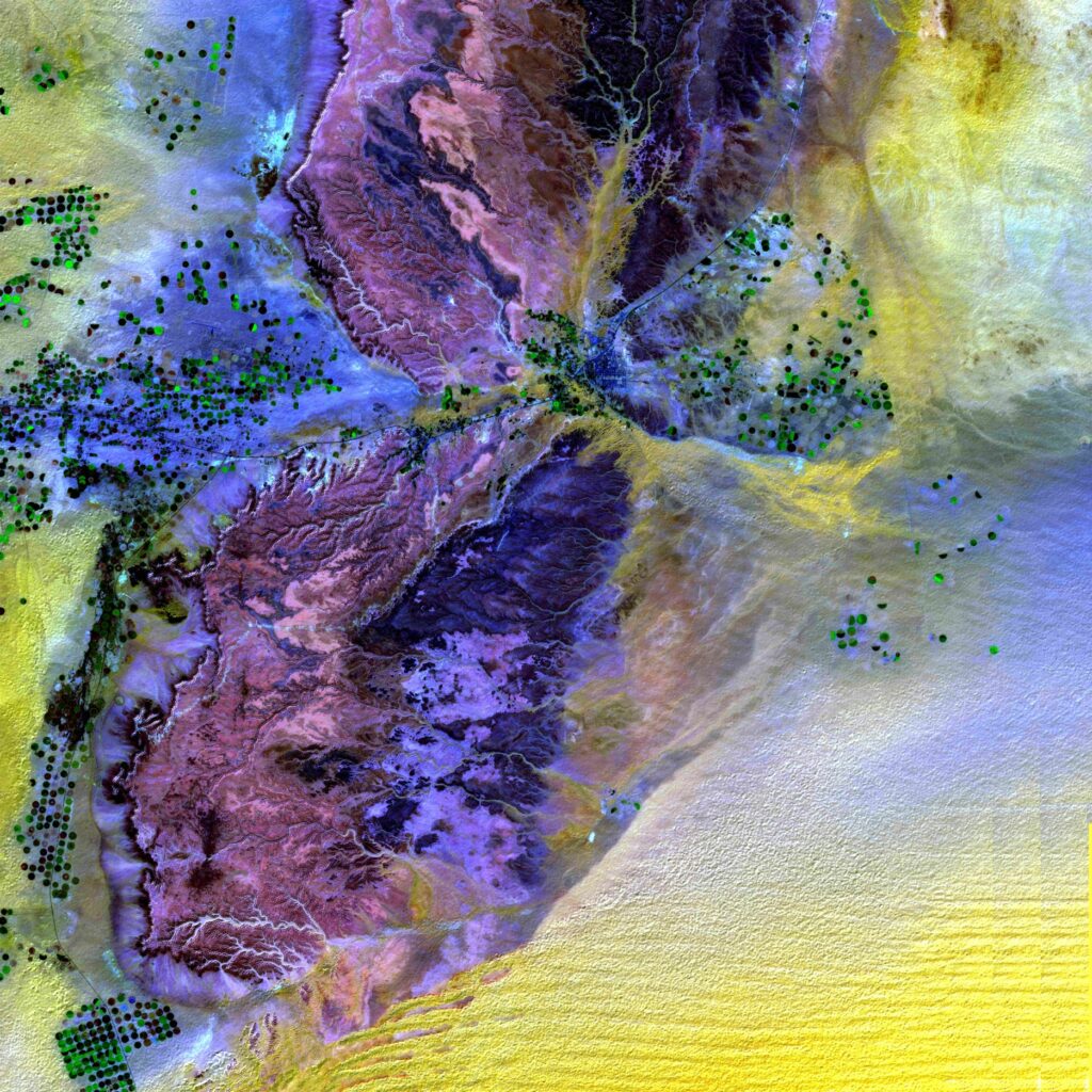
Arabia Saudita – Rub’ Al Khalì
Il Rub’ al-Khali (il Quartiere Vuoto in arabo) è uno dei più grandi deserti di sabbia, 2.220.700 km2 di superficie. Il clima è molto secco (meno di 100mm di pioggia/anno, e molto caldo con temperature maggiori di 40°C). I cordoni formati dalle dune, alte 100 m, sono di colore giallo dorato, continui e distanti l’uno dall’altro parecchie decine di metri. Importanti riserve d’acqua favoriscono l’impianto di colture irrigue, come i datteri, i banani, gli agrumi, e moltiplicano le colonie agricole. Degli innaffiatoi giganti su perno sono situati in corrispondenza delle zone cerealicole di forma circolare (cerchi verdi di 600 m di diametro circa).
Saudi Arabia – Rub’ Al Khalì
Rub’ al-Khali (the Empty Quarter in Arabic) is one of the largest sand deserts, 2,220,700 km2 in surface. The climate is very dry (less than 100 mm of rainfall/year, and very hot, with temperatures above 40°C). The cords formed by the dunes, 100 m high, are golden yellow in colour, continuous and several tens of meters apart from each other. Important water reserves favor the planting of irrigated crops, such as dates, bananas and citrus fruits. Giant watering cans on pivots are located in correspondence with the circular cereal-growing areas, visible in the image as green circles approximately 600 m in diameter.
.
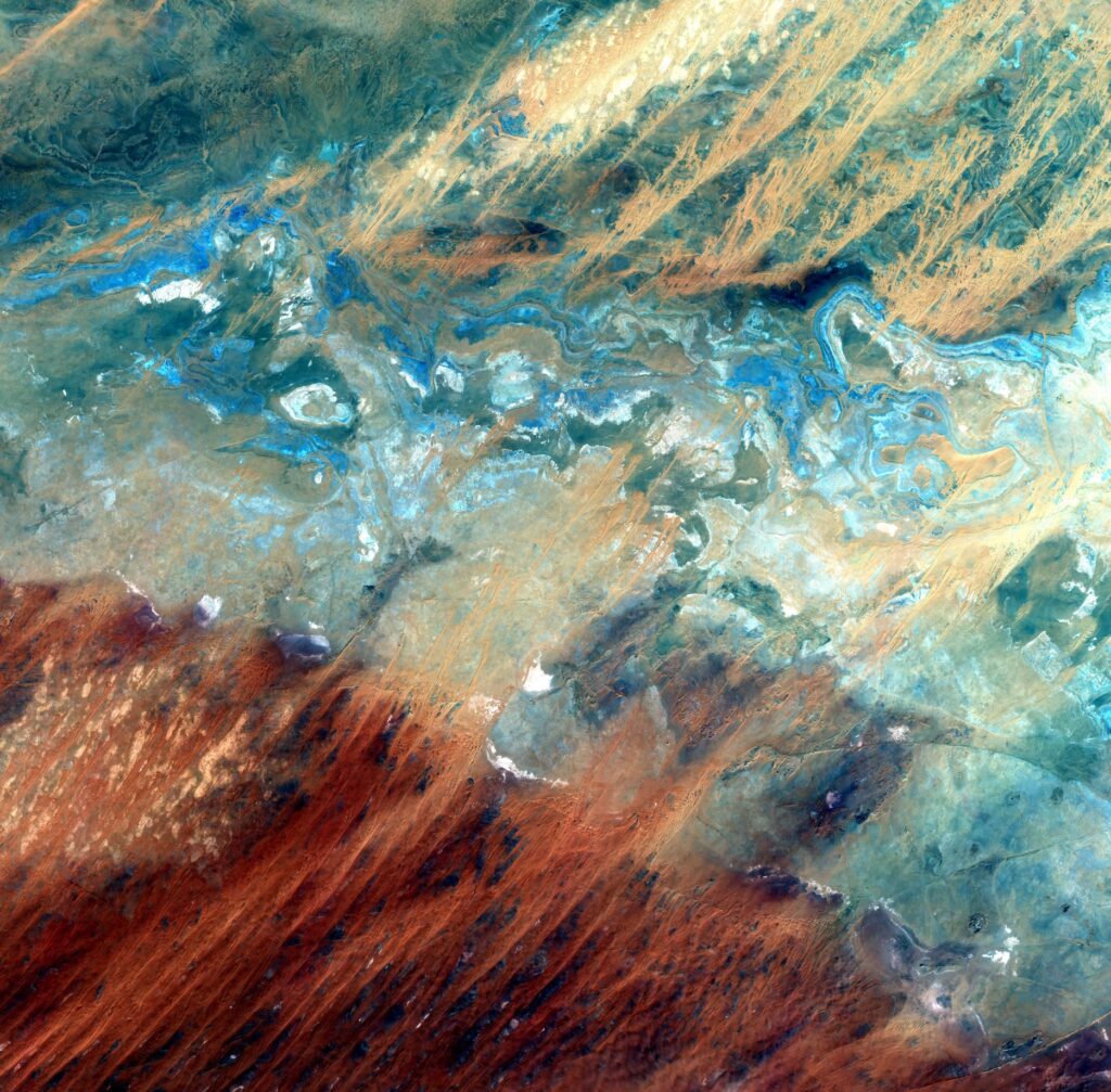
Mali – Sahara
L’area a 100 km a nord delle miniere di sale in Mali al confine con l’Algeria è caratterizzata da cordoni di dune orientate secondo la direzione dei venti dominanti (alisei) e da barcane (dune a forma di falce). Le tonalità rossastre indicano che la sabbia spesso lascia scoperto il sottostante altipiano roccioso. Le zone più chiare sono zone di depressione, in parte riempite da depositi di evaporiti (sali ottenuti dalla lisciviazione dei suoli).
Mali – Sahara
The area 100 km north of the salt mines in Mali on the border with Algeria is characterized by sand dunes oriented according to the direction of the prevailing winds (trade winds) and by barks (sickle-shaped dunes). The reddish hues indicate that the sand often leaves the underlying rocky plateau exposed. The lighter areas are depression zones, partly filled by deposits of evaporites (salts obtained from leaching of soils).
.
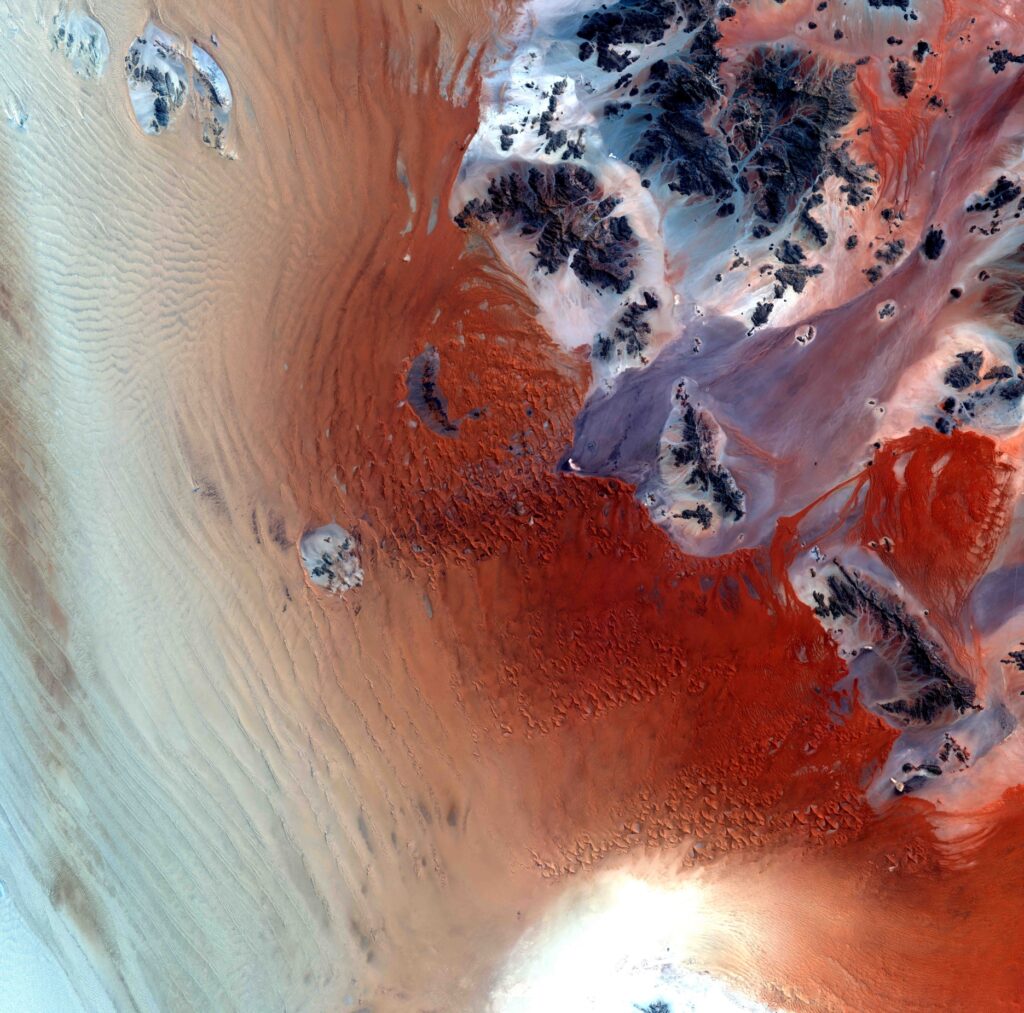
Namibia – Namib
Localizzato sul limite australe dell’oceano Atlantico, a sud-ovest della Namibia, tra Walvis Bay a nord e il fiume Orange a sud, il deserto costiero della Namibia si estende per centinaia di kilometri. Questo deserto è molto arido (pochi mm di pioggia/anno) e caratterizzato da una struttura a barcane, cordoni di dune molto mobili orientati nel senso dei venti associati alla corrente oceanica del Benguela. Gli affioramenti rocciosi testimoniano, sotto la sabbia, la presenza di uno zoccolo costituito di rocce metamorfiche. Questa parte del deserto della Namibia è situata nel cuore di una zona diamantifera molto protetta.
Namibia – Namib
Located on the southern edge of the Atlantic Ocean, south-west of Namibia, between Walvis Bay to the north and the Orange River to the south, Namibia’s coastal desert extends for hundreds of kilometers. This desert is very arid (a few mm of rain/year) and characterized by a barque structure, very mobile dunes oriented in the direction of the winds associated with the Benguela ocean current. The rocky outcrops testify, under the sand, to the presence of a base made up of metamorphic rocks. This part of the Namibian desert is located in the heart of a highly protected diamond zone.
.
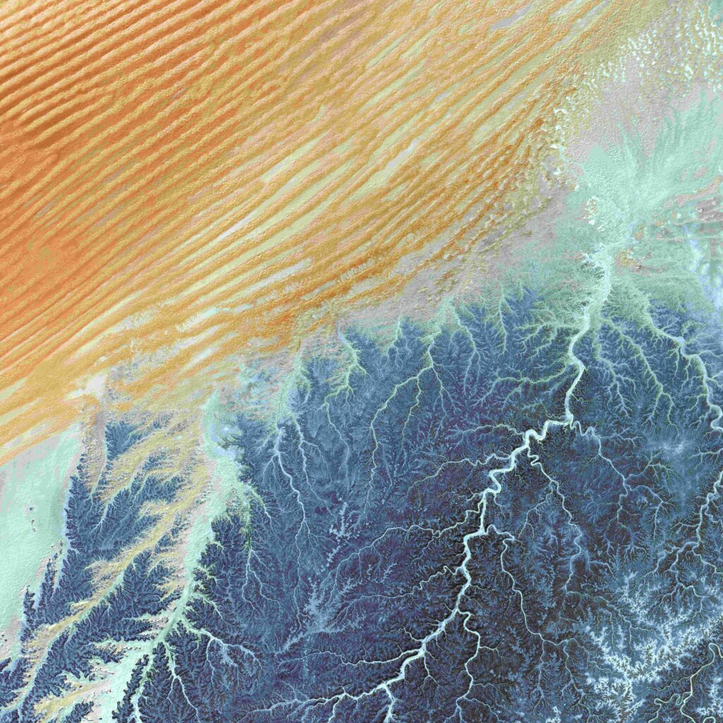
Australia – Grande deserto sabbioso
Il grande deserto sabbioso è situato a nord-ovest dell’Australia, 200 km a nord del tropico del Capricorno. E’ ricco di depressioni interne di origine eolica, sul fondo delle quali ristagnano alcuni laghi salati come il Tobin, in blu al centro dell’immagine. Le precipitazioni sono vicine a 200 mm/anno. Le dune allungate da est verso ovest riparano in alcuni posti la vegetazione arbustiva di tipo xerofilo. La struttura geomorfologica è costituita da granito molto alterato, ricoperto da una corazza lateritica che dà questo strabiliante effetto patchwork di colori che ci fa pensare ad una pittura rupestre.
Australia – Great sandy desert
The Great sandy desert is in the North-West of Australia, is situated 200 km North to the Tropic of Capricorn. It is rich of depressions created by wind currents, with some salt lakes, often dried out as the Tobin Lake, blue coloured, in the centre of the image. Rainfalls are near to 200 mm/year only. East-West stretched dunes are shrub-like vegetated in some of their parts. The lithological structure of this desert consists by altered granites covered by a lateritic crust that offers an amazing patchwork of colour effects, which sometimes might resemble a cave painting.
.
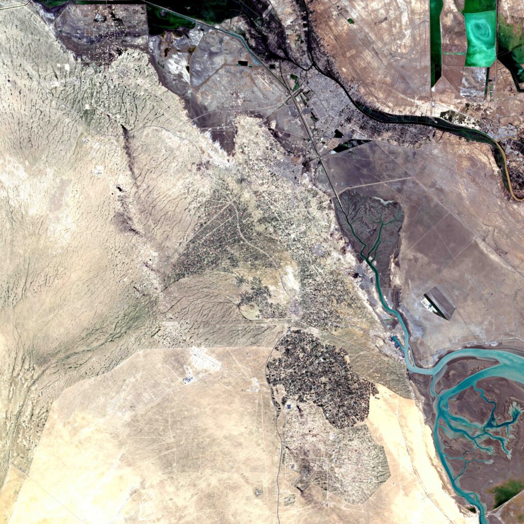
Deserto del Kuwait/Irak
Deserto all’estremità settentrionale del golfo Persico, a cavallo tra Irak e Kuwait. I toni beige e marrone indicano il passaggio dalle sabbie aride (inondabili) alle zone costiere fangose litorali, passando per suoli paludosi e appezzamenti irrigati. Le infrastrutture risaltano in questo paesaggio spoglio. Si identificano strade, oleodotti e canali, come anche le saline rettangolari. Anche il bacino e gli insediamenti di Umm Qasrs sono distinguibili dai meandri del canale Abd’Allah.
Kuwait/Irak – Desert
Desert at the northern end of the Persian Gulf, between Iraq and Kuwait. The beige and brown tones indicate the transition from arid (floodable) sands to muddy coastal areas, passing through marshy soils and irrigated plots. The infrastructure stands out in this stark landscape. Roads, pipelines and canals are identified, as are rectangular salt pans. The basin and settlements of Umm Qasrs are also distinguishable from the meanders of the Abd’Allah channel.
.
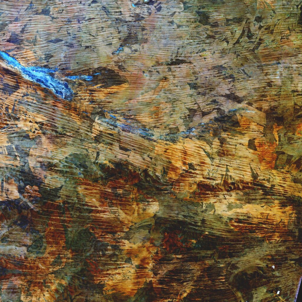
Arabia Saudita – Tuwayk
Il Deserto Arabico è una vasta zona desertica che va dallo Yemen al Golfo Persico, dall’Oman alla Giordania e all’Iraq. Occupa la maggior parte della Penisola Araba ed è una immensa riserva di petrolio. L’immagine sotto è un ingrandimento molto spinto di una zona desertica poco distante dalle città de La Mecca e Ryad. Le forme derivano dall’erosione nel tempo per effetto sia delle scarsissime piogge che del vento sulle rocce affioranti rendendo il paesaggio spettrale ma affascinante.
Saudi Arabia – Tuwayk
The Arabian Desert is a vast desert area that extends from Yemen to the Persian Gulf, from Oman to Jordan and Iraq. It occupies most of the Arabian Peninsula and is an immense oil reserve. The image below is a very high enlargement of a desert area not far from the cities of Mecca and Ryad. The shapes derive from erosion over time due to both the very low rainfall and the wind on the outcropping rocks, making the landscape ghostly but fascinating.
.
 using WordPress and